> For the complete documentation index, see [llms.txt](https://docs.carto.com/llms.txt). Markdown versions of documentation pages are available by appending `.md` to page URLs; this page is available as [Markdown](https://docs.carto.com/carto-user-manual/maps/exporting-data.md).
# Exporting data
With Builder, you can export your map data in multiple file formats: **CSV**, **GeoJSON**, **GeoPackage**, **GeoParquet**, **KML** and **Shapefile**. This lets you take a filtered dataset straight into the tools you already use without any manual conversion. This functionality respects all the filters you set using the feature selection tool, widgets, or SQL parameters, and the exported file includes detailed attributes and, if applicable, a geometry column.
## **Configuring what can be exported**
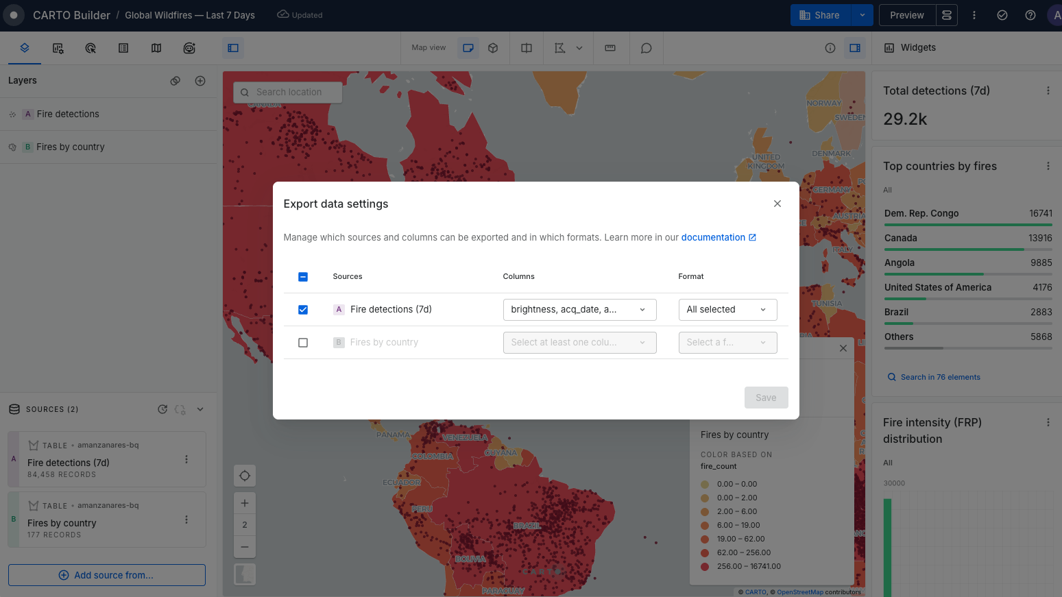
As an Editor, you control which data can be exported from your map and how:
* **Exportable sources:** Choose which data sources are eligible for export. This includes data sources that power widgets or SQL parameters but have no visible layer, which can now be exported too.
* **Exportable columns:** For each eligible source, whitelist the specific columns that can be exported, so sensitive attributes never leave your data warehouse.
* **Available formats:** For each eligible source, select which file formats are available for export. You can enable multiple formats per source, and your users will pick one format per export. Sources without a geometry column, or without a layer on the map, can only be exported as **CSV** or **Parquet**. The same applies if the geometry column isn't among the exportable columns.
## **Exporting data as an Editor**
The export viewport data button is located in the three dots, at the right top corner. It should be enabled as long as there are exportable data sources in Builder.
**How to export:**
1. Click the 'Export data' button. This considers the current viewport extent and any applied filters.
2. In the export window, select the data source(s) you wish to export and, for each, the file format.
3. Each selected source generates a job in the activity panel. You can monitor export progress here while continuing your work.
4. Once an export job is complete, click on it in the activity panel to download the file(s).
{% hint style="info" %}
**Bucket considerations**
For **CARTO Cloud**, CARTO automatically manages buckets and data exports. Be aware that for exports from Snowflake and Redshift sources, the AWS cluster needs to match the organization's CARTO Cloud region. Check your CARTO Cloud region in [Settings](/carto-user-manual/settings.md).
For **Self-Hosted** deployments, a bucket owned by the customer needs to be configured, and exports from BigQuery connections require it to be a Google Cloud Storage bucket. Learn more in [Configure your own buckets](/carto-self-hosted/configuration/data-and-storage/configure-your-own-buckets.md).
{% endhint %}
## **Enabling export for Viewers**
To allow viewers of your map to export data:
1. Navigate to the 'Map settings for viewers' button located next to the 'Preview' button.
2. Turn on 'Export viewport data', to enable viewers using the export viewport data functionality.
3. Publish your changes.
## **Exporting data as Viewer**
Viewers can export data following these steps:
1. Click the export icon located at the top left corner.
2. Choose the data source(s) to download and the file format from the modal window.
3. Each source's export creates a job for tracking. Monitor the progress in the dedicated section.
4. Upon completion, click on the export job and download the file(s).
{% hint style="warning" %}
**Export limitations**
* **Spatial Index** data sources (H3, Quadbin) can only be exported as **CSV** or **Parquet**.
* GeoJSON, Shapefile, GeoPackage and KML exports fail if the file grows beyond **4 GB**. CSV and GeoParquet aren't subject to this limit, so use them for large exports.
* Shapefile supports a single geometry type and files up to 2 GB. Use GeoPackage for sources that mix points, lines and polygons, and GeoParquet for large exports.
* **Pre-generated tileset and raster** data sources don’t support export.
{% endhint %}
{% hint style="info" %}
Admins can disable exporting data from Builder maps for the whole organization from the [**Governance**](/carto-user-manual/settings/organization-governance.md) settings.
{% endhint %}
---
# Agent Instructions
This documentation is published with GitBook. GitBook is the documentation platform designed so that both humans and AI agents can read, navigate, and reason over technical content effectively. Learn more at gitbook.com.
## Querying This Documentation
If you need additional information that is not directly available in this page, you can query the documentation dynamically by asking a question.
Perform an HTTP GET request on the current page URL with the `ask` query parameter, and the optional `goal` query parameter:
```
GET https://docs.carto.com/carto-user-manual/maps/exporting-data.md?ask=&goal=
```
`ask` is the immediate question: it should be specific, self-contained, and written in natural language.
`goal` is optional and describes the broader end goal you are ultimately trying to accomplish on behalf of the user. GitBook uses it to tailor the answer towards what is most useful for that goal.
The response will contain a direct answer to the question and relevant excerpts and sources from the documentation.
Use this mechanism when the answer is not explicitly present in the current page, you need clarification or additional context, or you want to retrieve related documentation sections.



 located next to the 'Preview' button.
2. Turn on 'Export viewport data', to enable viewers using the export viewport data functionality.
3. Publish your changes.
## **Exporting data as Viewer**
located next to the 'Preview' button.
2. Turn on 'Export viewport data', to enable viewers using the export viewport data functionality.
3. Publish your changes.
## **Exporting data as Viewer**

 located at the top left corner.
2. Choose the data source(s) to download and the file format from the modal window.
3. Each source's export creates a job for tracking. Monitor the progress in the dedicated section.
4. Upon completion, click on the export job and download the file(s).
{% hint style="warning" %}
**Export limitations**
* **Spatial Index** data sources (H3, Quadbin) can only be exported as **CSV** or **Parquet**.
* GeoJSON, Shapefile, GeoPackage and KML exports fail if the file grows beyond **4 GB**. CSV and GeoParquet aren't subject to this limit, so use them for large exports.
* Shapefile supports a single geometry type and files up to 2 GB. Use GeoPackage for sources that mix points, lines and polygons, and GeoParquet for large exports.
* **Pre-generated tileset and raster** data sources don’t support export.
{% endhint %}
{% hint style="info" %}
Admins can disable exporting data from Builder maps for the whole organization from the [**Governance**](/carto-user-manual/settings/organization-governance.md) settings.
{% endhint %}
---
# Agent Instructions
This documentation is published with GitBook. GitBook is the documentation platform designed so that both humans and AI agents can read, navigate, and reason over technical content effectively. Learn more at gitbook.com.
## Querying This Documentation
If you need additional information that is not directly available in this page, you can query the documentation dynamically by asking a question.
Perform an HTTP GET request on the current page URL with the `ask` query parameter, and the optional `goal` query parameter:
```
GET https://docs.carto.com/carto-user-manual/maps/exporting-data.md?ask=
located at the top left corner.
2. Choose the data source(s) to download and the file format from the modal window.
3. Each source's export creates a job for tracking. Monitor the progress in the dedicated section.
4. Upon completion, click on the export job and download the file(s).
{% hint style="warning" %}
**Export limitations**
* **Spatial Index** data sources (H3, Quadbin) can only be exported as **CSV** or **Parquet**.
* GeoJSON, Shapefile, GeoPackage and KML exports fail if the file grows beyond **4 GB**. CSV and GeoParquet aren't subject to this limit, so use them for large exports.
* Shapefile supports a single geometry type and files up to 2 GB. Use GeoPackage for sources that mix points, lines and polygons, and GeoParquet for large exports.
* **Pre-generated tileset and raster** data sources don’t support export.
{% endhint %}
{% hint style="info" %}
Admins can disable exporting data from Builder maps for the whole organization from the [**Governance**](/carto-user-manual/settings/organization-governance.md) settings.
{% endhint %}
---
# Agent Instructions
This documentation is published with GitBook. GitBook is the documentation platform designed so that both humans and AI agents can read, navigate, and reason over technical content effectively. Learn more at gitbook.com.
## Querying This Documentation
If you need additional information that is not directly available in this page, you can query the documentation dynamically by asking a question.
Perform an HTTP GET request on the current page URL with the `ask` query parameter, and the optional `goal` query parameter:
```
GET https://docs.carto.com/carto-user-manual/maps/exporting-data.md?ask=