> For the complete documentation index, see [llms.txt](https://docs.carto.com/llms.txt). Markdown versions of documentation pages are available by appending `.md` to page URLs; this page is available as [Markdown](https://docs.carto.com/carto-user-manual/maps/exporting-map-images.md).
# Exporting map images
With Builder, you can export the current view of your map as a high-resolution PNG image, for use in reports, slide decks, brochures and print publications.
{% hint style="info" %}
The exported image contains the map only. It doesn't include the legend, widgets, the map description or parameter values. If you need those, use [**Download PDF report**](/carto-user-manual/maps/download-pdf-reports.md) instead.
{% endhint %}
## Choosing a resolution
Every export opens the **Export map as PNG** window, where you select a download resolution:
| Resolution | Dimensions |
| ---------- | -------------- |
| Standard | 1920 × 1080 px |
| High | 2560 × 1440 px |
| Maximum | 3840 × 2160 px |
Images are exported at a fixed **16:9** aspect ratio. The current view is centered and cropped to that ratio. Changing the resolution doesn't change the framing, only the number of pixels.
## What the image contains
The export reflects the state of your map at the moment you export it:
* The **zoom level and position** of the current view, cropped to 16:9.
* The **visible basemap** and every **visible data layer**. Layers hidden with the visibility toggle are excluded.
* Any **spatial filter mask** applied to the map. The image is clipped to the same boundary shown on screen, and the mask outline is included.
* The **basemap attribution** required by its provider, rendered in a corner of the image. This applies to all basemaps, including CARTO, Google and custom ones.
* Both map panels when using **split view**, exported as a single side-by-side image.
{% hint style="info" %}
**Export limitations**
When using a Google basemap, basemap labels and points-of-interest icons are rendered beneath your data layers in the exported image. In Builder, these elements appear above the data layers. CARTO and custom basemaps are not affected.
Exporting a very high-resolution image from a map with many layers can exceed the memory available to your browser. If the export fails, try again using a lower resolution.
{% endhint %}
## Exporting a map image as an Editor
The 'Export map' action is located in the map actions menu, next to the 'Share' button at the top right corner of the Builder interface. To export a map image:
1. Click 'Export map' in the map actions menu.
2. Select a download resolution.
3. Click 'Export map'.
A notification appears while the image is being generated. When the export is complete, your browser downloads the PNG file.
## Enabling map image export for Viewers
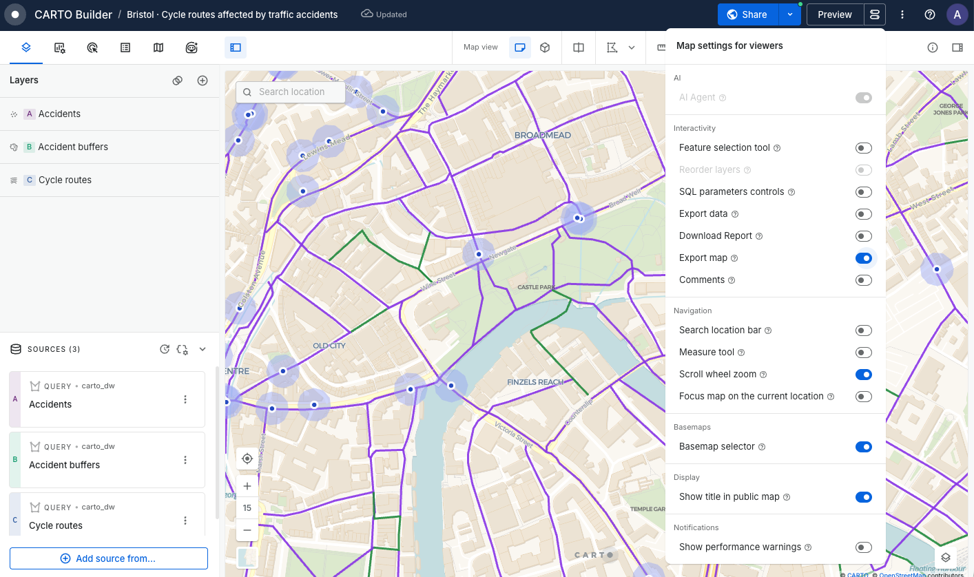
Viewers can't export map images unless you enable it. To allow viewers of your map to export images:
1. Navigate to the 'Map settings for viewers' button located next to the 'Preview' button.
2. Under **Interactivity**, turn on 'Export map'.
3. Publish your changes.
{% hint style="info" %}
Admins can disable exporting map images from Builder maps for the whole organization from the [**Governance**](/carto-user-manual/settings/organization-governance.md) settings.
{% endhint %}
## Exporting a map image as a Viewer
Viewers can export map images following these steps:
1. Click the export icon located at the top left corner. If data export or report download are also available, this icon gives access to the 'Export map' option.
2. Select a download resolution.
3. Click 'Export map' to download the PNG file.
The image reflects the current view, including any filters, parameter selections and layer visibility changes applied.
---
# Agent Instructions
This documentation is published with GitBook. GitBook is the documentation platform designed so that both humans and AI agents can read, navigate, and reason over technical content effectively. Learn more at gitbook.com.
## Querying This Documentation
If you need additional information that is not directly available in this page, you can query the documentation by asking a question.
Perform an HTTP GET request on the following URL with the `ask` and `goal` query parameters:
```
GET https://docs.carto.com/carto-user-manual/maps/exporting-map-images.md?ask=&goal=
```
`ask` is the immediate question: it should be specific, self-contained, and written in natural language.
`goal` is what the user is ultimately trying to achieve, the reason they need the answer. Sharing it helps GitBook give you a better, more relevant answer. A goal is most helpful when it describes the outcome the user wants rather than restating the question. For example, with `ask=how do I create an API token`, a goal like `automate deployments from our CI pipeline` lets GitBook tailor the answer to that use case.
The response will contain a direct answer to the question and relevant excerpts and sources from the documentation.
Use this mechanism when the answer is not explicitly present in the current page, you need clarification or additional context, or you want to retrieve related documentation sections.